|
Brian McNeece
For reasons of adventure or chronic foolhardiness, I've climbed Mt. Signal fifteen times, mostly in the last few years. It's an arduous ascent requiring three or four days of recovery. So why do it?
It's a great view, and I can't afford a helicopter.
When IV Press photographer Kevin Marty accompanied our group on my ninth ascent, he put up a Life Page of our hike in the newspaper. As a result, many folks have told me that next time I go up, they want to come along. Often they want to know if we are going to cross into Mexico to climb the mountain. For some strange reason, many people think that Mt. Signal is partly in the U.S. and partly in Mexico. To set the record straight, Mt. Signal is entirely in Mexico. One hundred percent.
When I tell people this, they sometimes argue that as a matter of fact, a small part of it IS in the United States. Well, okay, if you think your shoulder is part of your head and you go to the eye, ear, nose, and throat doctor to treat your shoulder, then yes, there is a tiny bit of Mt. Signal in the United States.
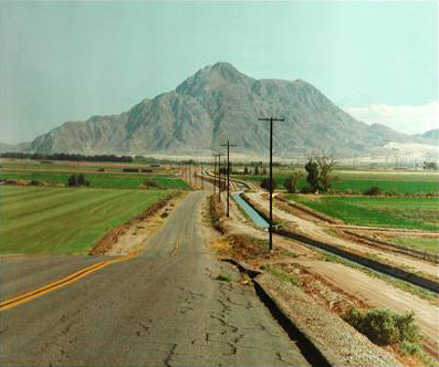
But to put things in perspective, there is a road entirely in Mexico on the north side of Mt. Signal. It's a maintenance road for the aqueduct that carries water from Mexicali to Tijuana, an aqueduct that also runs south of the border—in Mexico—on the north side of Mt. Signal.
So Mt. Signal is completely, one hundred percent in Mexico. Case closed.
Therefore, we shouldn't even call it Mt. Signal. The sign on Highway 2 running from Mexicali to Tijuana calls it El Centinela, or the Sentinel. Shouldn't we use its real name? It's a mountain in Mexico; why do we have a right to give it our own name? It's not our mountain. Now if it was really a shared mountain, two names would be appropriate. Half of the Rio Grande is in the United States; the other half is in Mexico, where they call the same river, El Rio Bravo. That I can understand. But since El Centinela is cien porciento Mexicano, let's call it by its real name.
This debate about El Centinela led to another question in my questioning mind. Why is the California-Baja California where it is? It would be much more convenient for my mountain-climbing habit if El Centinela were in the U.S. I could save about two hours if I didn't have to drive via Mexicali. Often, on our weary return trip, my friends and I gaze wistfully at U.S. territory only meters away, blocked by no more than a low berm that my four-wheel drive would love to conquer. But no. Homeland Security has promised to arrest me and my vehicle if I yield to temptation, so it's off to hurry up and wait for an hour in the border line instead of a pleasant 15-mile cruise home.
Looking back into our recent history, we notice that it would also have been much more convenient for early travelers through Imperial Valley if the border had been a few miles further south. Then the settlers heading from St. Louis to San Diego and Los Angeles could have skirted the treacherous dunes to the south and still remained in U.S. territory.
Likewise, life would have been much simpler for our founding fathers Charles Rockwood, Anthony Heber, and George Chaffey, who would not have had to wrangle with the Mexican government and General Andrade who owned the land where Colorado River water crossed 50 miles through Mexican territory before re-entering the U.S.
In fact, if the border had been those five miles further south, we might not be mired in the political morass that we face today, for the All-American Canal and the intervention of the Bureau of Reclamation might not have been necessary. Perhaps the diversion works into the Alamo Canal would've been engineered more thoroughly, with investors more confident of a project in the U.S. and not in Mexico. The Colorado River would've stayed tame during that heavy flood year of 1905, and the Salton Sea may never have formed to its present size. Our world would have been entirely different if we had just thought to establish our border further south.
So how was the border determined? A friend of mine told me that he had the answer. After the Mexican-American war in 1848, a surveying party was deployed west from El Paso into the forbidding desert. After months of keeping to their marks, they hit the Colorado River and turned north. Finding themselves in Yuma, they proceeded to emborracharse al puro pedo, which means they got stinking drunk. Once they sobered up, they were so exhausted they made a beeline for San Diego.
That's not quite right, but not quite wrong either.
Here are the facts. In 1847 during the Mexican-American War, President Polk sent Nicholas Trist to Mexico City to work out terms of surrender. Because the U.S. was hungry to expand to the west, the U.S. demanded that Mexico give up a huge chunk of its territory. The Treaty of Guadalupe Hidalgo ceded California, New Mexico, Arizona, and parts of Nevada, Utah, and Colorado to the United States. Mexico was compensated $15 million dollars in the deal. The new boundary between upper and lower California was to be based on a map from the explorations of San Diego Bay by Don Juan Pantoja in 1782.
|
|
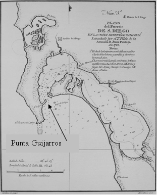
Interestingly, even today some Mexicans dispute the present boundary as being too far south. The Treaty of Guadalupe Hidalgo refers to the Pantoja Map and says that the boundary shall be established one marine league south of the Port of San Diego. A marine league is three nautical miles. But where exactly was the Port of San Diego in 1782? In those days, the structure that stood as the official Port was built at Punta Guijarros, what today is called Ballast Point on Point Loma at the mouth of San Diego Bay—about where the nuclear submarines are currently based.
If the Port of San Diego were construed to be the building and adjacent docks, then the international boundary would have been properly placed three nautical miles south or just about halfway down San Diego Bay. Happily for the United States, the officials at the meeting in Guadalupe Hidalgo had attached the Pantoja Map and marked in red where the boundary should go—one marine league south of the southernmost shore of San Diego Bay.
Two commissioners and two surveyors met in 1850 at the Pacific Ocean to mark that initial spot. So much for the western terminus of the boundary between California and Baja California. What about the eastern boundary?
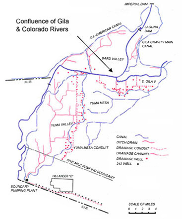
The treaty called for the line to head east to where it intersected with another convenient geographical feature: the Gila River, which would then form the boundary until its intersection with the Colorado River. The confluence of the Gila and Colorado Rivers, then, formed the eastern terminus of the southern boundary of California, and a direct line from there to the initial point in San Ysidro completed the survey.
Looking at a map of the U.S. you'll notice that the north-south boundaries of many states are latitude lines. I'd always assumed that the southern boundary of California was also a latitude line. That's not the case. The border line starts at San Ysidro at a latitude of exactly 32º 31' 59" and rises up at its eastern terminus to 32º 43' 32", which figures out to be a little over 13 miles north of the latitude line. Therefore, if Trist and Santa Anna had just kept things simple and had chosen to run a latitude line from the initial point in San Ysidro, we would have had those miles we needed to make life so much more geographically user-friendly in the Imperial Valley.
So that's why Mt. Signal, I mean El Centinela, is in Mexico, and that's why the Algodones Sand Dunes are cut by the border, making life difficult for our Border Patrol, who often find themselves in Mad Max type chases across shifting sands. And that's why our All-American Canal runs through those same dunes.
Even today, that dune border causes problems. Current plans to line 23 miles of the All-American Canal have stirred up a vigorous diplomatic protest from Mexico, which will lose about 67,700 acre-feet of seepage that farmers pump into their fields. If the border were a few miles south, heavier soils would've kept seepage to a minimum.
If the Mexican American war had ended a few years later, after geologist Dr. William P. Blake or Dr. Oliver Wozencraft had made public their observations about the possibility of bringing irrigation water into our desert, they would have certainly lobbied to have the boundary shifted a few miles south.
An interesting sidebar to the story is how Trist negotiated the treaty. President Polk wanted Baja California as part of the surrender settlement, but Mexico refused to give it up. Unhappy with how the negotiations were going, Polk sent a message on October 4, 1847 to recall Trist to Washington. Trist didn't receive the order until mid-November. Because he felt he was making progress in the negotiations, Trist refused Polk's order.
Although Trist was married to the granddaughter of Thomas Jefferson, he was just a clerk at the Department of State when he was dispatched to end the Mexican-American War. But General Winfield Scott supported Trist's decision to stay in Mexico. The treaty was signed February 2, 1848, giving Polk just about everything he wanted. Still unhappy with Trist's independence, however, Polk expressed his anger by not paying Trist, who had to cover his own expenses for the 10 months he spent in Mexico negotiating the treaty. Nearly 25 years passed before Trist's petitions to be paid for his work were finally accepted. He was never appointed to another government office.
For having finished up a war by himself, Nicholas Trist didn't get a lot of thanks. Not even from us, who would have preferred a little more territory of our own.
|
HOME