OF THE COLORADO DELTA by Guy E. Hazen In the broad expanse of land just east of the Coast Range in San Diego County, California, lies Imperial Valley, extending from Coachella Valley in the north and southward into Mexico. The valley has a width of up to 60 miles. These valleys have been created by faulting along the line of the San Andreas Rift which extends throughout the valleys and on into the Gulf of California in Mexico. The present land surface of Imperial Valley and part of the Coachella valleys is part of the Colorado River Delta region. Today the delta is forming in the northern end of the Gulf of California. The central portion of the valley lies below sea level and the Salton Sea occupies the lowest part. Much of the Central Valley is under irrigation, the soil having been laid down in fairly recent times by the Colorado River. |
|
From time to time the Colorado River changed its channels, thereby causing the water from the river to flow first one way then another. One of the last shifts of channel was to the north where it formed a body of water known as Lake Coachella. The old shore line may be seen at many places, one of which is at Travertone Point along U.S. 99—some 22 miles south of Indio, California, the highest mark being sea level. This was before the advent of the white man; there are signs that Indians were living there while the lake was filled to its highest point. The last time the river flowed north was in 1905. The river broke through the dikes of the Southern Pacific Railroad along the Colorado River near Yuma, flowed northward through Imperial Valley and flooded the sink. Later the Colorado River changed its course and flowed direct into the Gulf of California. The flow of the Colorado River continued to run into the gulf for a long enough period that the Coachella dried up, leaving a dry bed from which salt was taken, making what is now known as the Salton Sea. Land movements along the San Andreas Fault during Pleistocene times have raised much of the west side delta deposits upward, so that much of it today is above sea level. Much erosion since the uplift has cut into the delta deposits, exposing the various strata to view. These are known as the bad lands, which are mostly composed of silts and clays deposited in deep water, and stream-washed sands and gravels deposited adjacent to or above deep water, most of which were from the Colorado River.
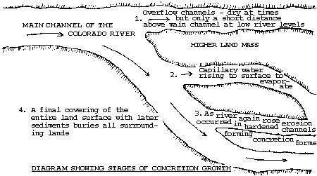
According to Fay in the "Dictionary of Geological Terms" a concretion is a spheroidal or discoidal aggregate formed by the segregation and precipitation of some soluble mineral like quartz or calcite around a nucleus which is often a fossil. This definition, while true for most concretions, is not true in all cases. The various forms of sand crystals will have the form of the crystal shape of the mineral which was precipitated. This is generally a hexagonal, like calcite, from which most sand crystals are formed. Another form is that of barite. As this article is mostly about the spiral concretions, the various general forms will not be discussed except in relation to the shape of the spiral and sand spike concretions. On the west side lying adjacent to the Coast Range are the uplifted sediments of the Colorado Delta deposits, which were mostly formed in late Pleistocene time. These are composed of clays and sands, the red clays representing a deposit in water of depths where only the fine particles were carried out by the river current. The sands and gravels represent land or shallow water deposits. As the spiral and other sand concretions occur in the sands this formation will be in relation to the forming of the concretions. These sands are composed in most part of the rock material derived from the land area which the Colorado River and its tributaries drain, except those deposits close to the Coast Range, which are of local nature. Recent alluviums cover much of the area, so that only the higher portions have the Pleistocene deposits exposed. These exposures lie mostly in valleys extending into the Coast Range, or close to the ends of the extending ridges. The extent along the Coast Range reaches from below the border of Mexico and up to the end of the Santa Rosa Mountains, a distance of 70 to 100 miles. There is an exposure on the east side of the Salton Sea and some clays and sand of the river among the upturned sediments the north side of Coachella Valley. As the type of concretion to be described occurs only in gravels brought down by the river it is there that the delta deposits will be discussed. At the time the delta was being formed the waters of the Colorado River probably being split into diverse channels which would shift more or less periodically, but leave exposed portions only a few inches above the water level of the newer channels. These channel beds consisted of various gravels and clays which were carried down into the basin. A certain amount of water would rise by capillary action from the ground water to the surface of the exposed channel sands, where it was then evaporated by the winds and the sun. In consequence of this evaporation of water, there was formed close to the surface a deposit of mineral salts which consisted mostly of calcium carbonate, thereby forming a hard, firm crust on the surface, of a few inches in thickness. |
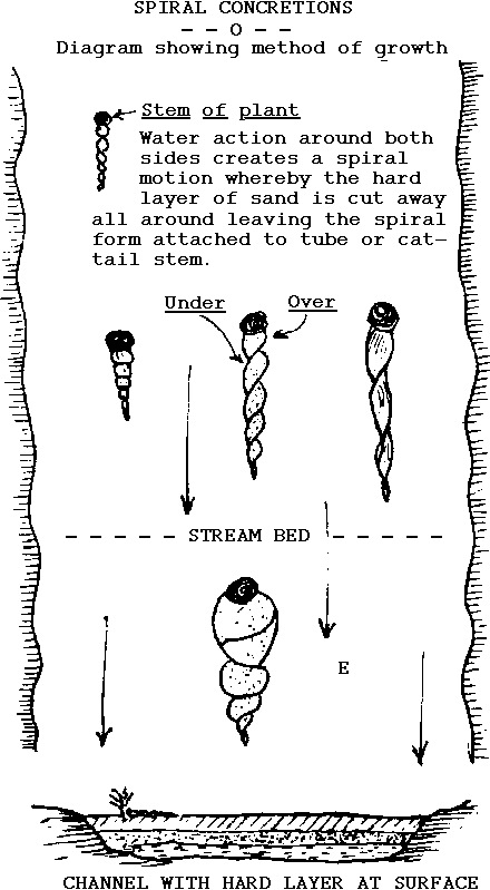
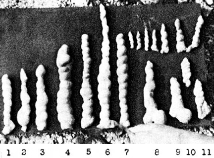
Owing to obstructions being built in the channels at times adjacent to this area, the waters overflowed thinly over these marginal land channels, gradually eroding and causing small channels to be cut through this hard surface at numerous places, and gradually carrying away the accumulated hard top layer until there were small strips and patches left in line with the stream flow. These were then carved further into various streamlined shapes, some of which were long tapering spikes, with a rounded head on the upstream side, tapering down to a point in a symmetrical form. These today are found in the exposed sediments and are called "sand spikes." Another type which was formed by a slightly different method formed just below a stem or plant growth of some kind which grew out of the sands. Action of the water rushing around this obstruction set up a spiral motion, thereby fashioning a spiral-like, tapering sand projection back of the plant stem. These were sometimes right-hand, or left-hand twists, or at other times, not being a complete spiral form, resembled a braided form, because the water action apparently did not get underneath and make a complete spiral action. There are various other shapes which, because of slightly different conditions, would make different forms from those mentioned. However, all concretionary forms found in valleys are not necessarily fashioned by this method. Before these remnants of the former hard layer were completely eroded away, began, and proceeded into the present day, exposing various strata of the underlying delta deposits of sandstone clays, etc. This erosion laid bare the former, eroded-out figures which were shaped by the delta channel waters and which having a greater resistance to the erosion, are left exposed among the canyons and hills of the present day bad lands of western Imperial, Borrego and Coachella Valleys. The sand spike form has also been found above Davis Dam in the river sand terrace of the Colorado River. It was possibly during the late Pleistocene epoch that the mountains on the west side of the valley were raised to some undetermined elevation above their former height, and the portion of delta sediments adjacent to them also raised above their former position. Land surface erosion then began, and proceeded into the present day, exposing various strata of the underlying delta deposits of sandstone clays, etc. This erosion laid bare the former, eroded-out figures which were shaped by the delta channel waters and which, having a greater resistance to the erosion, are left exposed among the canyons and hills of the present day bad lands of western Imperial, Borrego and Coachella Valleys. The sand spike form has also been found above Davis Dam in the river sand terrace of the Colorado River. Some concretions are formed by crystallization of calcium carbonates within the sand in a radiating aggregate. The sand spikes had more added to them by a calcium carbonate crystallation after burial, by precipitation of a solution passing through the strata in which they occurred. This gave the knobby form to those along the Mexican Border and above Davis Dam, Nevada. When found, these sand spikes and spirals are all pointed in the direction in which the water flowed in the channels. There is a crystalline type of concretion like sand crystals formed in various shapes within the sands of the Old Colorado River channels.
Sand spikes are also found close to the Mexican border near Signal Peak, west of El Centro, and the spiral concretions are found in the exposed sediments at the lower end of the Santa Rosa Mountains just west of the Salton Sea. It is not possible to see any of the sand spikes or spiral concretions in place anymore, as collectors have carried all away. However, many other forms of concretions can be seen throughout the badlands. The accompanying drawings will try to convey the process whereby the various concretions were formed just before burial. The map will show the general location of certain types of concretions of interest. Not all of these locations on the maps can be reached by cars with two-wheel drive. As erosion continues, more concretions will be exposed, but it will be hard to dig them out, as they mostly have the surrounding sand adhering to them, so that one cannot get a good specimen. These and most of the concretions only occur in the sands brought in by the Colorado River. Some of these sands are as far north as Indio, but not many of the well formed and smooth shaped concretions occur there, or in the Box Canyon area. The following areas have well formed concretions in them: the Mexican border's Superstitious Mountain, Carrizzo Creek, Fish Creek, lower Borrego Valley, 17 Palms, and Palm Wash area. Water now covers much of the area above Davis Dam where sand spikes were found. Many of the spikes from this area can be seen at Anna Parks Museum on the north side of the Boulder Dam Highway just on the edge of Las Vegas, Nevada. Concretions show the stratification of the sand in a lengthwise direction. A crystalline type of round concretion occurs in the same strata as the spiral concretion, but the sand is finer and darker, having been formed previous to the spirals and carried into and buried with the others. (References: American Journal of Science April, 1936; Desert Magazine, July, 1949; Nature Magazine, February, 1938.) |