CONCRETIONS NEAR MT. SIGNAL, LOWER CALIFORNIA.
by Kenneth B. Garner
ABSTRACT.
Sand-calcite concretions having somewhat the outward form and appearance of an ancient mace, first described by H. W. Nichols, in 1906 [1], occur chiefly in the Palm Springs formation (Tertiary) of the Lower Colorado Desert region. Material similar to the above, but of much greater average size, is also noted from Tertiary beds of the Mojave Desert in the Red Rock Canyon area. In the Lower Colorado Desert occurrence large numbers of concretions have been weathered out from the original Tertiary beds, and, through probable wave and current action, were re-deposited in Pleistocene beds, where they are now exposed and where they exhibit collectively a uniform type of orientation, horizontal, and parallel to the ancient shoreline upon which they lie.
Petrographic studies show the concretions to consist of well-sorted sand grains cemented together with crystalline calcite, in which respect, they are similar to the well known sand-calcite crystals from South Dakota and elsewhere. However, in the case of the concretions, it is evident that they were not formed at haphazard angles throughout the sand matrix, since the original bedding planes of the latter are generally parallel with the concretion stems.
Available evidence thus far observed does not suggest a logical explanation for the fusion of the simple, spherical and cylindrical unit-concretions into the odd-shaped compound types here described, but it is felt that anyone trying to explain the origin of concretions in general, may well take into account the observations herewith presented.
INTRODUCTION.
An unusual type of sandstone concretion (see Figs. 3 and 4) occurs near Mt. Signal, on the United States-Mexican Boundary Line, a few miles southwest of Calexico, California. Recent active interest in this matter dates back to the year 1929 at least. Identical material, almost certainly from the same general locality, was described by Dr. H. W. Nichols of the Field Columbian Museum, Chicago, in 1906. However, Mr. Nichols based his paper upon the rather meager evidence to be gained from a series of five specimens "from Salton, California," which had been submitted to him by a Mr. Herbert Brown, of Yuma, Arizona. No description of the locality or of the occurrence of the material was submitted to Mr. Nichols, and, with good reason, he, therefore, states that "Lack of data prevents discussion of the nature or origin of these concretions from Salton, California."
The following description is based upon field studies of the locality and upon a small amount of laboratory work on selected specimens. Assistance in the preparation of this paper was rendered by Prof. A. O. Woodford, of the Department of Geology, Pomona College, Claremont, California, and by Mr. Richard Merriam, also of Pomona College. Likewise, the writer is indebted to Dr. H. W. Nichols of the Field Museum, and to Mr. R.W. Burger, of the Texas Oil Co., at El Centro, California, for their many helpful comments on the problem, and for permission to quote from their writings and personal communications concerning the concretions. Nichols[2], in his description of the concretions from near Salton, says of them:
These concretions are formed of sand cemented by calcite, and are, therefore, of the type of the well known Fontainebleau and Saratoga Springs concretions, from which, however, they differ in several respects. The Salton concretions take the form of an irregularly botryoidal ball from which projects a stout tapering stem in such wise that the object assumes the shape and proportions of an ancient mace. The change from head to stem is abrupt, much as if the stem were driven into a hole bored in the head, and there is even a slight annular depression where the stem enters. The botryoidal appearance of the head is due to a compound structure—each head being built up from a number of spheroidal concretions grown together. While there is but little flattening of the concretion as a whole, the subordinate spheroids are much ßattened and also elongated in the line of the principal axis of the concretion. The specimens have a very rough surface from the presence in large numbers of rhombohedral points of arenaceous crystals of calcite. These points suggest that these concretions, like those from Devil Hill, Wyoming, described by Barbour[3], are aggregates of moderately large crystals. Lines of stratification intersect the specimens in such a way as to indicate that the principal axes lie conformably with the strata in which they form. The slight flattening of the complete individual, as well as the greater ßattening of the subordinate spheroids of the head is in the plane of bedding of the surrounding sand.OCCURRENCE.
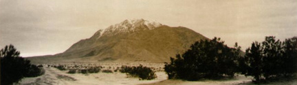
The type occurrence lies athwart the United States-Mexican International Boundary Line (see Fig. 1), about 12 miles southwest of Calexico, California. At this point, the outcropping concretionary beds occupy land filed upon as placer ground. That portion of the land lying within California is described in the Notice of Claim filed in a monument as being the S.W. one-quarter of Sec. 19, T. 17S., R. 13E., Imperial County, California.
Type samples of the unusual concretions described belong were found in place in a small area of sandstone lying perhaps 100 yards south of the Boundary Line. This sandstone will hereafter be termed the "Primary Bed." At another small locality on the United States side of the Line, and at about an equal distance from it, are found concretions eroded out of the primary bed but now occurring in poorly stratified, largely unconsolidated beach sand of Pleistocene (?) age. This small occurrence is bisected by a road over which gravels for roadbuilding operations have been hauled from the area. In contrast to the previously mentioned primary bed, this deposit will be termed the "Secondary Bed."
In the year 1929, and during the progress of certain roadbuilding operations in the Imperial Valley, large numbers of these concretions were exposed in the secondary beds, and were then again brought to the attention of investigators. One of these, Mr. S. C. Edwards,[4] of Colton, California, has since published a brief paper dealing with the subject.
At the primary locality studied by the present writer, the concretions are found only a few feet above the base of a series of sandstone beds, probably the Palm Springs Formation of Woodring[5]. The underlying bed rock is granitic. The primary Tertiary sediments themselves, lying upon the adjacent slopes of Mt. Signal, have been rather deeply eroded, and show some deformation due to regional uplift movements.
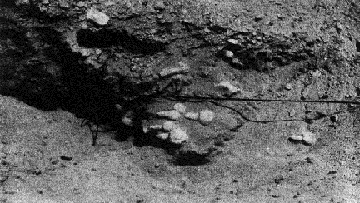
Fig. 3. Photo illustrating an actual exposure of the concretions in place, as explained under Fig. 2.Small remnants of the formation have been noted at elevations as high as 250 feet above sea level around the lower slopes of Mt. Signal, but apparently the concretions are restricted to a narrow portion lying between elevations 40-62 feet. The outcropping primary beds are noticeably harder and more resistant to Weathering than the softer secondaries in the same area, and their yellow-brown color likewise contrasts with the prevailing gray or drab colors of the latter beds. The two outcropping formations here form a portion of the old Quaternary (Blake Sea) shore line, a marked physiographic feature of the Imperial basin. Primary sandstone outcroppings containing concretions in great abundance may be seen in the small stream channels immediately east and south of the International Boundary Line marker at elevation 62.97 feet in the midst of the area. Here may be found large numbers of concretions, mostly of the spherical 'accretion' type, along with fewer numbers of the drumstick or macelike forms.
Mr. R. W. Burger, in a written communication to the writer, dated December 10, 1934, as a result of his personal investigations into the geology of the Palm Springs Formation in various parts of the Imperial Valley, makes the following observations regarding the occurrence of the concretions:
. . . these peculiarly shaped concretions are quite abundant in the Palm Springs Formation in almost every locality where it is exposed. I have seen them in the San Felipe Hills, the Yuha Buttes, at Superstition Mountain, and in the Carrizo Creek and Vallecito Wash region I find in my notes the following observations concerning them:1. They generally occur in fine grained, soft or friable pink sandstone.
2. They often contain pebbles at the center, though some contain a calcite-lined cavity, and many, perhaps most, appear to have no nucleus whatever.
3. Fossil wood is contained in the same beds in many places fragments of which are sometimes found in the centers of concretions. This type of concretion generally has a more regular shape than the ones in which you are interested (the mace-like forms etc.) however.
4. Bedding planes appear to be continuous through the concretions in many, but perhaps not all cases."[6]
Thus it may be seen that the primary occurrence of these concretions, as shown by the extensive observations of Mr. Burger, is a quite broad and general one, and that it is by no means confined to the Mt. Signal locality. Covering both types of beds at the Mt. Signal locality, is a recent deposit of coarse fanglomerate material from six to ten inches in thickness, somewhat indurated by carbonate cementing substances, and derived chießy from the adjacent Mt. Signal itself. Also included within the capping are a few small and well-rounded beach-pebbles of a type commonly found only in the higher portions of the primary Palm Springs formation.
Beneath the fanglomerate capping, a vertical North-South cross-section taken through one of the small remnants of the secondary bed, has an appearance similar to that shown in Fig. 2, in which the relative sizes of the concretions are greatly exaggerated with regard to total depth and size of the matrix sand.
A most curious condition, characteristic of this secondary bed, but, as yet not observed in the primary deposit, is the constant North-South horizontal orientation of the concretions as they lie in the unconsolidated secondary sand.
Excavation of the bed further reveals a maximum depth of four feet of the loose sand and included concretions, below which lies a stratum of red clay and silt, in which no concretionary material has been found. The sand which encloses the concretions shows little or no sign of indication or of true stratification, there being merely a small amount of crossbreeding evident within the mass. On the contrary, the enclosed concretions are plainly stratified, in most instances parallel to their long body-axes. Individuals, or groups of them, often showing great similarity of outward form and size characteristics, and sometimes numbering up to twenty or more specimens in a place, have been found clustered together as the sand was shovelled away from around them. Perhaps only a few inches, or at the most, only a few feet away, would be found another cluster of the same general type of concretions, but differing widely in actual form. A most interesting feature, shared in common by all specimens as they were revealed in this secondary bed, was their horizontal orientation as noted above. Regardless of size or minor structural details all specimens of the mace-like or club type were found to lie with their "heads" to the South and towards the primary beds, while their tail-like stems of course pointed to the North. This directional orientation here roughly parallels that of the old Lake Cahuilla (Blake Sea)[7] shoreline which is a prominent physiographic feature of the region. Specimens to the estimated total of several thousands, all with similar physical details, have been exposed and removed from this single, small locality, measuring something less than 200 feet square, and which doubtless contains still greater numbers of them. It is believed that the unusual arrangement and concentration of these large numbers of concretions has been brought about through the action of longshore currents in the comparatively narrow and shallow channel which connected the almost landlocked Blake Sea with the Pacific Ocean during Pleistocene times. If so, these currents, acting upon the low-lying Miocene sediments of the Palm Springs Formation, eroded out the more resistant concretions from the soft matrix, gently transported them little by little (stem end first) in the direction of the new secondary shore deposit a short distance farther along the beach line, there to drop and cover them again with clean sand. Evidence tending to support such a theory is seen in the fact that several specimens of concretions excavated from the secondary bed were found encrusted with a thin coating of algal travertine, such as grew abundantly on rock surfaces exposed to the freely circulating waters of this sea during its existence.
Laboratory investigations of the chemical and physical characteristics of the Mt. Signal concretions were first conducted by Doctor Nichols, and have since been continued by the writer, with the assistance of Professor Woodford and Mr. Merriam of the Pomona College geological laboratories Doctor Nichols[8], in commenting upon the problem of formation and growth of calcareous concretions, such as these of the Signal Mountain area, writes:
"The concretions form by the enlargement of calcite fragments in the sand into crystals. Such fragments of crystals build up into larger crystals by abstracting material for growth from nearly saturated solutions, reducing materially the saturation of the parent solution. Saturation may have been maintained by a gradual escape of carbonic acid so slow that deposition in concretions could prevent supersaturation, but I believe continual renewal of the saturated solution by circulation is a more reasonable explanation."Recent petrographic investigations of the internal, physical structure of representative specimens, as made at the Pomona College laboratories, confirmed those of Nichols, and revealed that each ball-like concretion is composed of the ordinary beach sand materials cemented together with crystallized, radiate calcite, and that each mace-like form consists of a "head" composed of sand grains cemented together by calcite crystals closely grouped into spherical, radiate structures generally united about a common center, and with a "stem" of the same composition, but in which the calcite crystals are grouped radially about a longitudinal, central axis. The latter, as shown by bedding planes which penetrate the structures, were commonly formed parallel to those planes of deposition, thus proving that the structures are not of stalactitic origin, as might be supposed.
                         TABLE I.

                                 EARLIER            NEW
                              DETERMINATION    DETERMINATION
 Specific Gravity of Solid          2.69             2.66
 Screen Size Test:

  40 -  50   mesh ............... 00.00%           15.00%
  50 -  60      " ............... 00.00%           15.00%
  60 -  80      " ............... 17.00%           15.00%
  80 - 100      " ............... 48.00%           15.00%
 100 - 150      " ............... 35.00%           15.00%
 150 - 200      " ............... 00.00%           15.00%

                                 100.00%          100.00%

 Percentages of Sand and Calcite:

 Sand         29.17%
 Calcite      70.83%

             100.00%
Spherical grouping of calcite crystals developed under proper conditions is a familiar and common occurrence, and the radiate cylindrical structure is not uncommon in true stalactitic forms of calcite, but as yet the combination of the two forms into a concretionary structure appears unique. However, similar crystallizations of calcite, barite, et cetera, in a sand matrix, have long been known from South Dakota, Oklahoma and elsewhere. Results of the earlier chemical laboratory investigations made by Doctor Nichols and of those more recently made at Pomona College, are embodied in the comparative tabulation (Table I).
In the above comparative table, showing the specific gravities, sizes of particles, and percentages of sand and calcite, values were computed upon material broken from the heads of representative specimens. The sand-calcite percentages were determined by treatment of weighed fragments with cold dilute hydrochloric acid, after which, the remaining insoluble sand particles were washed, air dried, and again weighed, the loss being figured as calcite. The relative percentages of the various sized particles were obtained by screening through standard mesh sieves.
With the aid of a Wentworth recording micrometer, a quantitative study was made of two thin sections cut from the head portion of a mace-concretion selected from the secondary deposit. The minerals present, together with their areal (volume) percentages are shown in the following Table II:
                        TABLE II.

                           Transverse      Longitudinal
                         Mineral Section      Section

    Quartz ................... 53.1%            42.2%
    Orthoclace ................ 2.3%             2.9%
    Plathioclace .............. 0.0%             0.4%
    Biotite and Iron Oxides ... 5.8%             3.1%
    Calcite Cement ........... 38.7%            51.4%

                               99.99%          100.0%
SUMMARY.
The occurrence of a type of arenaceous calcite concretion from near Mt. Signal, Lower California, first described by H. W. Nichols of the Field Museum, in 1906, is here explained in some detail. The concretions have been found to occur in both primary and secondary beds; specimens occurring in the latter type of bed exhibit a remarkable parallel directional arrangement which is wholly lacking among specimens in place in the primary bed. To account for this unusual parallelism in the secondary beds, it is suggested that it has been brought about through the agency of shore currents in an old Pleistocene sea acting upon concretion-bearing strata at or just below tide level; combined wave and current action thus served to erode and transport the concretions from their primary bed to the adjoining secondary locality at the same level. An outline of the manner in which such concretions might have been formed originally, as suggested by Nichols, is briefly sketched. Certain of the physical and chemical characteristics peculiar to these concretions are listed and described.
SAN BERNARDINO, CALIFORNIA.
REFERENCES:
[1.]Nichols, H. W.: New Forms of Concretions, in Field Columbian Museum, Geol. Ser. 3, 25-54, pls. 19-27, 1906.
[2.] Loc. cit., p. 25.
[3.] Barbour: Bull. Geol. Soc. Amer., Vol. XII, p. 165, 1902.
[4.] Edwards, S. C.: Sand Concretions from California, Rocks and Minerals, Vol. 9, No. 6, 82-83, June, 1934.
[5.] Woodring, W. P.: Distribution and Age of the Marine Tertiary Deposits of the Colorado Desert, Carnegie Inst., Washington, Pub. 418.
[6.] Since this report was first prepared, a further discovery of the same type of concretion, but of much larger size, 12-20 inches in diameter, has been made in the Ricardo (Tertiary) beds of Red Rock Canyon, Mojave Desert. AM. JOUR. SC.—FIFTH SERIES, VOL. XXXI, N0. 184, APRIL, 1936.
[7.] Blake, W. P.: "The Cahuilla Basin and Desert of the Colorado," in "The Salton Sea, A Study of the Geography, the Geology, the Floristics, and the Ecology of a Desert Basin," Carnegie Inst., Washington, Pub. 193, p. 6, 1914.
[8.] Personal communication, dated January 16, 1935.
Originally published in:
THE AMERICAN JOURNAL OF SCIENCE
APRIL, 1936. All rights reserved.